


All Products
-
Multifunctional Handheld Infrared Night Vision
-
Explosive Ordnance Disposal Robot
-
Miniature Reconnaissance Robot
-
Monocular Digital Night Vision
-
Digital Night Vision Device
-
Anti Sniper
-
Portable Radar
-
Patrol Recording Flashlight
-
Tactical Special Operations Equipment
-
Rifle Scope
-
Laser Rangefinder
-
Military Model
-
Tactical Gear
-
Inflatable Decoys
Infrared Handheld Night Vision Multifunctional For Hunting And Wildlife Observation


| Place of Origin | China |
|---|---|
| Brand Name | Particle |
| Model Number | NVD3000 |
| Minimum Order Quantity | 1 |
| Price | $17,000 |
| Payment Terms | T/T |

Contact me for free samples and coupons.
Whatsapp:0086 18588475571
Wechat: 0086 18588475571
Skype: sales10@aixton.com
If you have any concern, we provide 24-hour online help.
xProduct Details
| Infrared Detection Resolution | 640×512@12um | Resolution | 2592×1944@2.7um |
|---|---|---|---|
| Visible FOV | ≥3.2°×2.4° | Digital Zoom | 1×~4× |
| Working Time(Room Temperature | ≥10h | Operating Temperature | -40℃~+55℃ |
| IP Grade | IP67 | Customized Support | OED,ODM,OBM |
| Infrared Recognition Distance | Mid-Size Vehicle:≥2.8km; Standing Man:≥1km | Infrared Detector | 640×512@12um |
| Infrared Focal Length | 70mm | FOV | ≥6.3°×5.0° |
| Visible Light Recognition Distance | Mid-Size Vehicle:≥6.6km;Standing Man:≥3km | Visible Light Resolution | 2592×1944@2.7um |
| Visible Light Focal Length | 105mm | Visible Light Focal Length Adaptation Range | 50m~∞ |
| Visible Light | ≥3.2°×2.4° | Laser Ranging | (1)Minimum Range:≤50m; (2)Maximum Range:≥6km; (3)Precision:≤2m; (4)Accurate Rate:≥98%; (5)Repeat Frequency:≥0.5Hz |
| Laser Ranging Logic | Select To Display The First Or Last Target Capability Measured | Laser Ranging Wavelength | Human Eye Safety Band |
| Positioning Precision | ≤7m(CEP),≤10m(PE) | Magnetic Azimuth | ≤0.5°(RMS) |
| Target Positioning Accuracy | At 2km Of The Distance,≤20m(CEP) | Diopter | -4SD~+4SD |
| Working Time(Room Temperature) | ≥10h | Memory Storage | 32G |
| Weight | ≤1.6kg | External Interface Data | USB |
| External Interface Video | PAL | Communication | RS232 |
| Interface Type | Reserved Picatinny Rail | Defog | Support |
| Highlight | Infrared handheld night vision,handheld night vision Multifunctional,Hunting handheld thermal imaging scope |
||
Product Description
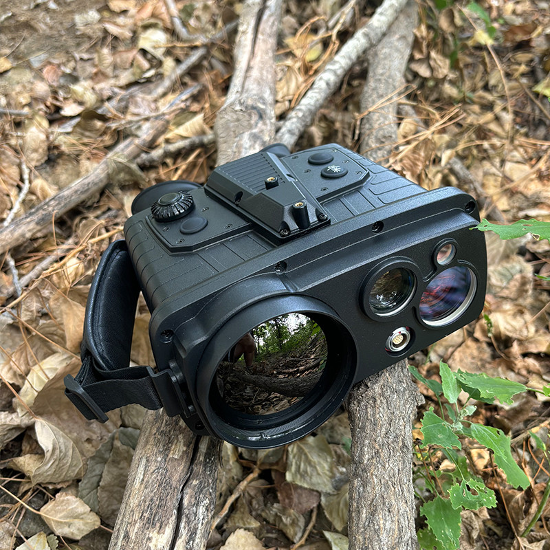
Multifunctional Handheld Infrared Night Vision
for Hunting and Wildlife Observation
APPLICATIONS
The JP NVD3000 is a highly functional binocular handheld uncooled thermal imaging telescope. Equipped with a thermal imaging detector and visible light sensor, it allows seamless switching between thermal and visible light images. With integrated satellite positioning, laser ranging, and an electronic compass, it provides accurate self-positioning and target positioning data. Ideal for field observation, surveillance, and target location acquisition, the JP NVD3000 is tailored to meet the requirements of diverse operational scenarios.
Technical Parameters
|
Product model |
NVD3000 |
|
Infrared |
|
|
Mid-Size Vehicle,km |
≥2.8 |
|
Standing Man,km |
≥1 |
|
Infrared detection resolution,Pixel@um |
640×512@12um |
|
Lens focal length,mm |
70 |
|
Infrared FOV,° |
≥6.3×5.0 |
|
Visible Light |
|
|
Mid-Size Vehicle,km |
≥6.6 |
|
Standing Man,km |
≥3 |
|
Resolution,Pixel@um |
2592×1944@2.7um |
|
Focal Length,mm |
105 |
|
Focal Length Adaptation Range,m |
50~∞ |
|
Visible FOV,° |
≥3.2×2.4 |
|
Defog |
Support |
|
Laser Ranging |
|
|
Minimum Range,m |
≤50 |
|
Maximum Range,km |
≥6 |
|
Precision,m |
≤2 |
|
Repeat Frequency,Hz |
≥0.5 |
|
Ranging Logic |
Select to display the first or last target capability measured |
|
Laser Wavelength |
Human eye safety band |
|
Positioning Orientation |
|
|
Positioning Precision,m |
≤7(CEP), ≤10(PE) |
|
Magnetic Azimuth,° |
≤0.5(RMS) |
|
Target Positioning Accuracy,m |
at 2km of the distance,≤20(CEP) |
|
Other |
|
|
Diopter,SD |
-4~+4 |
|
Digital zoom,× |
1~4 |
|
Working Time(Room temperature,h |
≥10 |
|
Memory Storage,G |
32 |
|
Operating Temperature,℃ |
-40~+55 |
|
IP Grade |
IP67 |
|
Weight |
≤1.6 |
* These parameters are for illustrative purposes only and are subject to change without prior notice due to product updates and improvements.
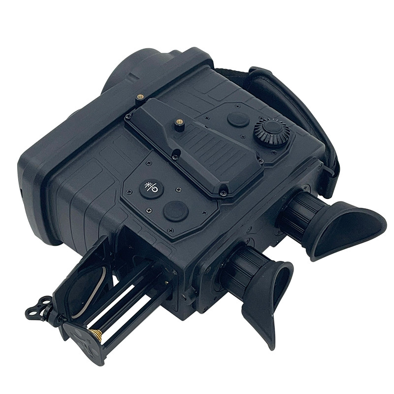
Product Details
![]()
► Thermal imaging observation mode and visible light observation mode can be switched with one click, and screen brightness, contrast, image quality enhancement, etc. can be personalized
► Supports guided search function after entering target coordinates
► PIP
► Supports fog penetration function in visible light (color, black and white) observation mode
► Laser ranging and real-time display of distance, longitude, latitude, elevation and other data of the measured target
► Relative ranging function supports relative distance calculation between targets
Recommended Products